Geocoding Tabular Data
The Problem
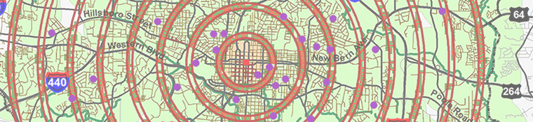
This exercise introduces you to the capabilities of ArcGIS to geocode address tabula data for GIS analysis which can provide valuable information and answers for research, marketing, planning, pattern analysis, etc. The objective of this exercise is to provide a professional GIS analysis for a local commercial company in Raleigh, N.C. which will locate their current customers in Wake County and provide accurate data as a basis for recommendations about the development of successful advertising strategies. They wish to use the analysis to make decisions about how they can expand their customer base in Wake County into areas outside their current customer area.
Strategies
This GIS analysis will be performed using ArcGIS 10.2.2 ArcMap and ArcCatalog to do geocoding analysis processes of ZIP Code and Street Address data for Wake County to make a map and database with up to date and accurate current customer location information as required for marketing purposes for a commercial enterprise to assist in expanding their customer base, especially in unrepresented areas.
The reference data to be used are:
- Client supplied "Customer.xls" address information in an Excel file format.
- "WakeCounty_ZIP_Code" shapefile and database files originally from the Wake County Government with the necessary table with zip code and address information for geocoding customer locations.
- "Wake County Boundary" shapefile and database files originally from the Wake County Government to limit the geocoding of customer locations to within Wake County.
- "Wake_County_Streets" shapefile and database file originally from the Wake County Government containing the necessary table with street address information for geocoding customer locations.
Methods
Part One: Geocoding ZIP Codes
1.
Save a blank ArcMAP map file to "My_Name".mxd.
2. The symbology
for any layers and features should be edited for ease of use at any time doing the process.
3.
Add the "Wake_County_ZIP_Code" file to the map and review its layer attributes table fields. Add the "Customers.xls" file to the map and review its attributes table fields.
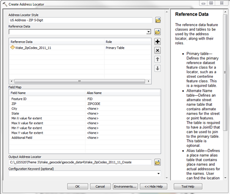
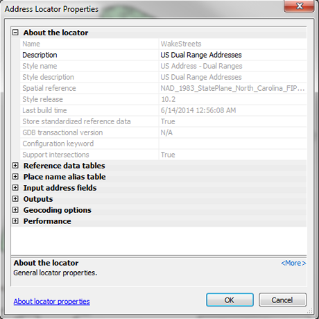
4. In ArcCatalog the first task is to use the New/Address Locator Tool and the Create Address Locator Tool to link to the ZIP Code layer and create a new address locator shapefile and add to map.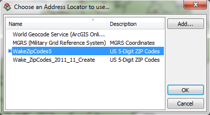
5.The new address locator file needs to be activated using the Geocoding Tool.
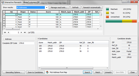
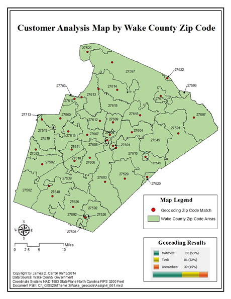
6. The second task is to perform a Batch Geocoding Process to prepare the "Customers.xls" file for geocoding. Use the Geocode Address Tool in the Table of Contents to configure the proper properties for this process. Run the Address Locator and Review the new "Wake_Customers_ZIP" shapefile geocoded address results for match, tied and unmatched addresses.
7.
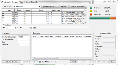
The Interactive Rematch Tool will be used to fix and rematch zip codes to increase the accuracy of the geocoding. Finally, the U.S. Postal Service's ZIP Code Lookup will be used to locate and rematched for attributes with missing ZIP codes.
8. Create a presentatation and save the new map file.
Part Two: Geocoding
1.
Save a blank ArcMAP map file to "My_Name".mxd.
2. The symbology
for any layers and features should be edited for ease of use at any time doing the process.
3.
Add the "Wake_County_Boundary" and "Wake_Streets" files to the map and review their layer attributes table fields. Add the "Customers.xls" addresses file to the map and review its attributes table fields.
4. In ArcCatalog the first task is to use the New/Address Locator Tool and the Create Address Locator dialog box to create new address locator as in Part One above, but with different properties specific to Streets.
5. Addresses can now be interactively located with the
Find button in the ArcMAP toolbar, and a Label Point added to the map with the Add Label Point tool. Three addresses will be added to the map using this process.
6. The second task is to modify the "Customers.xls" table to re-run the Batch Geocoding Process because the full street address needs to be in single field, but the present database uses multiple fields. The values must be concatenated by exporting a new database file named "Customers_Addresses", adding a new field named Address, using the Field Calculator to populate it.
7. The third task is to repeat the steps for Batch Geocoding for the "Wake_ Streets" layer and the new "Customer_Addresses"
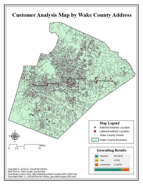
database file to output a new "Wake_Customer_Streets" shapefile. This new layer can be Reviewed and now edited for match, tied and unmatched addresses.
8.
The Interactive Rematch Tool will be used to fix and rematch addresses for this new file layer to increase the accuracy of the geocoding. Some data can be edited manually, such as incorrect zip codes and name abbreviations, etc..
9.
Create a presentation map and save the new map file.
Discussion
Geocode:- ZIP Codes
The accuracy of ZIP Code matching does not necessarily mean the street address will be the correct location. Missing and incorrect data will cause many Tied and Unmatched addresses which limits the usefulness of the analysis for full marketing usage. The analysis can have a potentially low percentage of accuracy, and this will result in extra time and expense to verify errors and correct the database to maximize its use for business and marketing purposes.
Geocode: Streets
The use of Streets analysis has potentially a much higher percentage of accuracy because more complete data is being use, it is not as dependent on one Field for accuracy. This does not mean it will not have errors, because the database can still contain errors or missing data which will require further research to verify and correct.
Another way to test the results is to take the same addresses and run a location check on-line with Google Maps or Wake County iMaps, etc. for verification.
Evaluation
Geocoded addresses is an important product for many businesses, industries, software, navigation systems, and other technologies; so it is very important to develop excellent GIS skills in this area. I know I will be able to use the skills and processes learned in this assignment to develop analysis strategies and processes to create static and on-line mapping projects. Because of the variety of locations, multiple subjects, and missing address information it will require some creativity with GIS and records research to create accurate databases and maps. Recently I had to track down unknown addresses in Raleigh, NC, and the only way to find the adddresses was by searching public property records to create an ownership history until finally an actual address was found. It is necessary to combine different knowledge and skills, some which are not specific to GIS, to achieve successful results. This assignment definitely shows that mapping accurate address locations can be a much more complicated process than people presume. The better and more accurate your data, the easier the process will be, plus the results will be at a higher quality level.