Working with US Census Data:
American Factfinder & Tiger/lines
The Problem
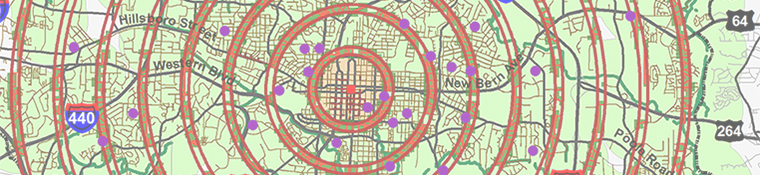
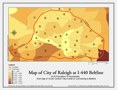
This exercise introduced the capabilities of ArcGIS for working with Census data Tiger/Line Shapefiles for geoprocessing data for analysis. The project mission is to develop a professional GIS analysis and thematic map(s) for the North Carolina Office of State Human Resources for the decision-making process of the State of North Carolina and other government departments. Because of the rapid population growth of the City of Raleigh, the Planning Department has requested an analysis of the number individuals 18 years old and over in households per 2010 Census Tracts which are inside or connecting to the I-440 Beltline.
Strategies
This GIS analysis will be done using ArcGIS 10.2.2 ArcMap, ArcCatalog, and MS Excel to process the Wake County 18 years and over population data table, then join it with the geographic Census Tract data to create a combined data file which will provide the data to be analyzed and computed for the specific requested Census Tract locations.
The data for this analysis will be obtained from the American FactFinder service website.
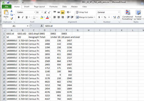
The Census data table to be used is, People: Basic Count/Estimate – Household & Family – P16 Population in Households by Age, 2010 SF1 100% Data. The file named DEC_10_SF1_P16_with_ann.csv contains the numerical data for under 18 years old, and 18 years old and over, for Wake County Census Tracts. I will use the GEO.id2 (Census Tract ID) and D003 (18 years and over) attributes to analyze the Wake County Census Tracts for population totals. The Wake County Census Tract geographic data in 2010 Tiger/Line Shapefiles format will be obtained from www.census.gov service, and file tl_2010_37183_tract10.shp includes a database file and other necessary files. I will be able to use the GEOID10, NAME10, and NAMESAD10 attributes for this population and age analysis. Additional data files for streets, major roads, and jurisdiction boundaries will be obtained from the City of Raleigh GeoPortal and Wake County GIS Data service websites.
Methods
Part One:
1.
Save a blank ArcMAP map file to "My_Name".mxd.
2.
Add the "Wake_MajorRoads.shp", "Wake_Tracts_2010. shp" (Census), "Wake_Jurisdictions_2014_5.shp", "Wake_Streets_2014_5.shp" to the Data Frame.
3. Verify and configure the State Plan Coordinate system for all layers.
4. In MS Excel open the "DEC_10_SF1_P16_with_ann.csv" and save as an Excel Workbook file. Review the file and edit to obtain the correct over 18 year old data with a GEOID10 containing an 11 characters field for geoprocessing.
5. Add the
new Excel file to the ArcMap Table of Contents.
6. Edit the Attributes Table of the
"Wake_Tracts_2010. shp" to have matching fields with new Excel file, then Join them by right clicking the "Wake_Tracts_2010" census tract layer, select Joins and Relates/Join, and then input the matching fields. The objective is to create a final Census Tract data file which will combine the geographic GEOID10 field and its shared attributes with the GEO.id2 (Census Tract ID) and D003 (18 years and over) attributes.
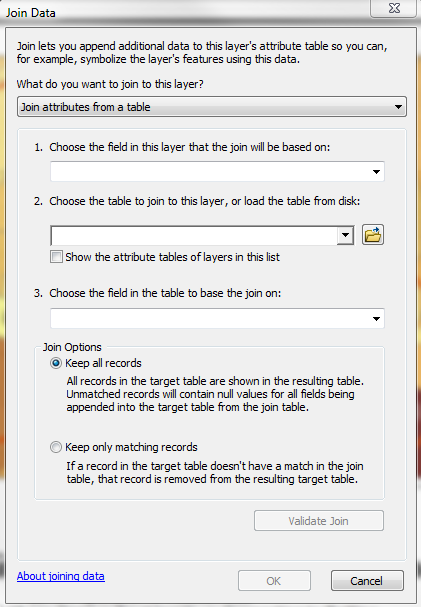
7. Analyze the new joined "Wake_Tracts_2010" layer. Open Properties and configure the symbology for the 18 years or older field Value, the Classification method, Symbol colors, Range, and Label values to produce a thematic map showing the 18 and over population data for the correct Census Tracts.
8.
Create a presentation map and save the new map file.
Discussion
The process should have been simple to do, but dealing with different software and file formats was a challenge because of the inability of 2010 Excel 2010 to output a csv file format. I tried using Libre spreadsheet software to reformat the CSV file, even created a database file, but there seemed to be compatibility issues with ArcGIS. I found it much easier to use any version of Excel, and then modify the Census Tract shapefile/table rather than the Excel table. The most challenging mapping issue was figuring out how to present the information clearly in a thematic map. There are many different ways to configure the value classes, plus there were also many Census Tracts. To make a readable and understandable map with limited graphic options is a real task with this type of data results. This is partly caused by software interface limitations and also some configuration limitations for color within ArcGIS. I tested many, many variations, but one which met all criteria was difficult to achieve.
Evaluation
The knowledge learned in this assignment will be very useful in the near future to assist in location research and design mapping. I think the only issue is whether complete data such as for specific ages, demographics, etc. is available. I looked for this issue when researching the data resources for this assignment, but American FactFinder never showed some types of data, such as specific age data, to be an available download for Wake County. I had proposed doing a GIS analysis to determine best locations based on population density, age, and other demographics in the City of Raleigh. This could be combined with IVR software/hardware technology and human behavior research methods to develop potentially very interesting investigative research.
If specific City blocks have better demographics, or developed better demographics, would they be considered prime locations for specific uses and planning criteria? Can the planning process be used to assist in pro-active endeavors to learn from and create market interest? The issue is, what data is needed and how can it be obtained? Such types of analysis for planning (public and private) requires that Census Tract, demographic, and many other types of data be used in combination with new research methods and technology for creating and developing successful short and long term planning, design, and decision-making processes.